Department of Structural and Geotechnical Engineering.
Portada » A platform to visualize the risk associated with earthquakes and tsunamis

Department of Structural and Geotechnical Engineering.
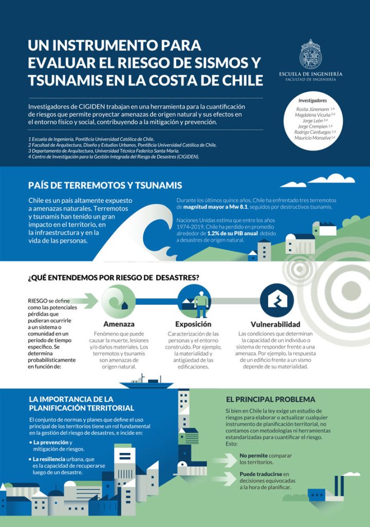
Territorial planning, that is, the regulatory framework that reviews and oversees the development and use of land in a given territory, plays a central role in disaster risk management. Even though Chilean law mandates the presentation of risk assessment reports for any territorial planning initiative, we lack standardized methodologies and tools to accurately quantify risks, curtailing our ability to implement preventive measures.
Professor Rosita Jünemann, along with a team of researchers from CIGIDEN (Center for Research on Integrated Disaster Risk Management), have dedicated extensive research to tackle this issue. How can risk be accurately assessed? What contributing factors need to be considered? Moreover, how can risk be quantified and visualized? Their proposal: a comprehensive platform called “ASISTE.”
The ASISTE platform enables visualization of risks associated with earthquakes and tsunamis within urban blocks using a variety of mapped information. To obtain quantitative data, ASISTE employs a risk assessment methodology that combines three key variables – threat, exposure, and vulnerability. This methodology has been implemented in a calculation engine called DRW (Disaster Risk Workflow), also developed by CIGIDEN, that generates risk results that can later be visualize in ASISTE. Threat refers to natural events like earthquakes and/or tsunamis that can cause structural damage; exposure considers the characterization of the built environment and the population residing in a defined location; and vulnerability assesses the ability of an individual, building, or system to respond to a threat. Thus, risk is understood as the potential consequences (losses or damages) that could affect a community or system over a specific period.
First, it simulates thousands of seismic scenarios considering the magnitude and frequency of potential events. For each scenario, it assesses the threat by calculating different earthquake and tsunami intensities for each urban block. Next, to determine exposure, it characterizes the buildings, infrastructure, or residents in each block. Then, considering the vulnerability of these exposed elements, it estimates physical damage (light, moderate, extensive, and complete) and evacuation times for a given scenario. Finally, ASISTE integrates all potential scenarios into the DRW calculation engine to conduct a probabilistic risk analysis.
The computational tool is structured into modules, each with its own data input and output. Each module operates independently and uses a numerical simulation model for every stage of the process. The standardization of inputs and outputs allows to automate the sequence of modules, from the initial rupture module to the calculation of physical damage and evacuation times.
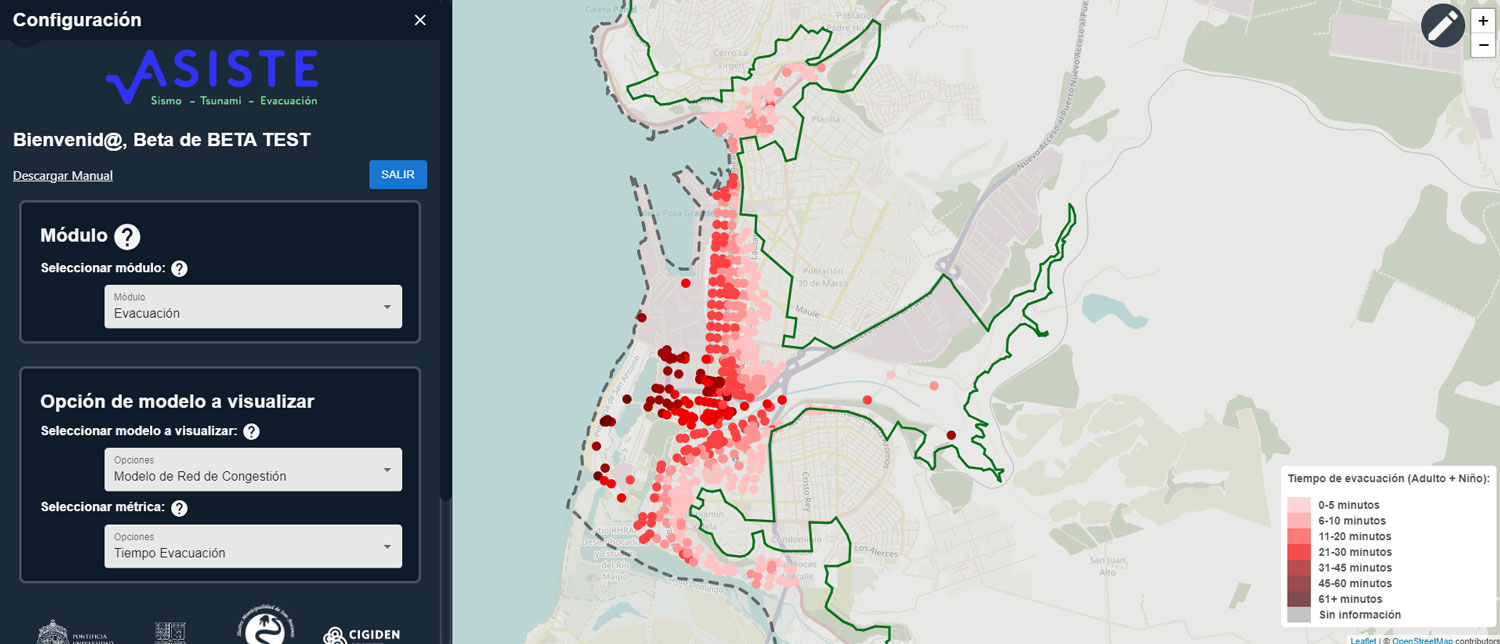
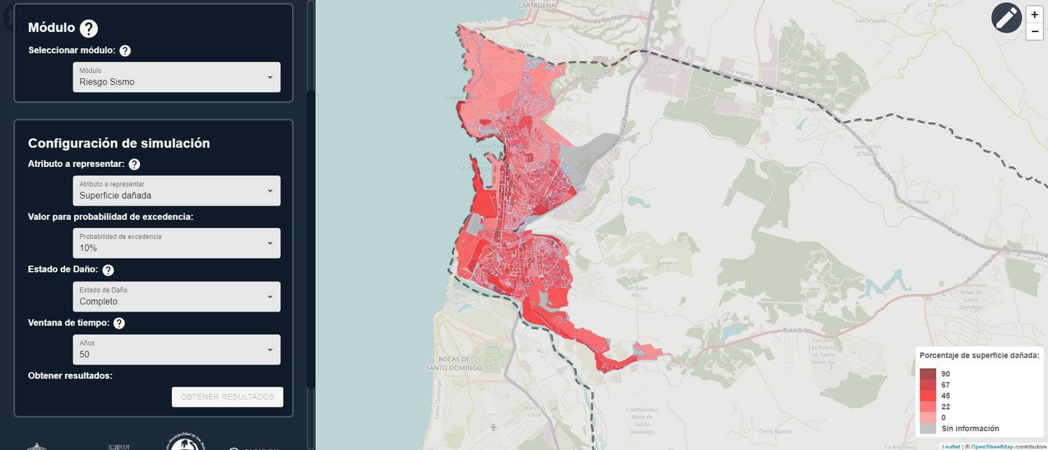
Snapshots of the ASISTE platform, displaying the “Evacuation module” (top panel) and “Seismic Risk module” (bottom panel).
Department of Structural and Geotechnical Engineering.
San Antonio was the first coastal city to implement ASISTE in a pilot study. The platform displays population exposure per urban block; the location, quantity, and characteristics of buildings; earthquake and tsunami threat intensities (considering maximum ground acceleration, arrival times, and flood depths); evacuation times to safe zones; and the different levels of damage sustained by buildings. This information enabled the identification of the city’s most critical areas.
Currently, this platform may be applied to risk assessment in Chile’s major coastal cities. Standardized results and metrics provided by ASISTE could greatly contribute to urban and regional planning, facilitating the design of more effective evacuation plans and emergency response protocols. Ultimately, it is expected that this platform will benefit the residents of a country that, due to its geophysical characteristics, will continue to experience earthquakes and tsunamis as part of its historical trajectory.
Department of Structural and Geotechnical Engineering.